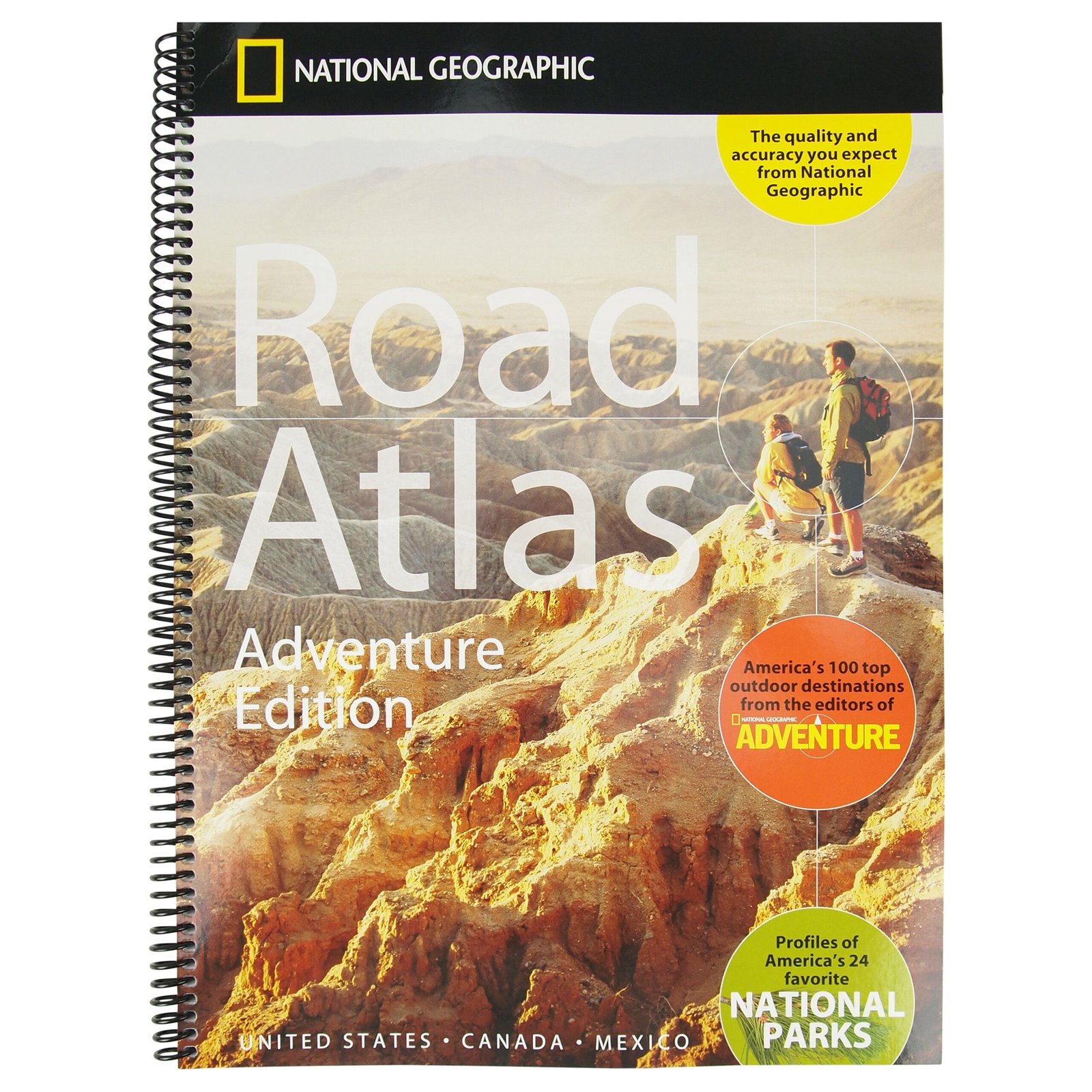
For anyone with a passion for travel, adventure, and the open road, the National Geographic Road Atlas 2025: Adventure Edition is more than just a collection of maps—it’s a gateway to discovery. As someone who has spent years navigating backroads, chasing sunsets, and seeking out hidden gems across the United States, Canada, and Mexico, I can confidently say this atlas is a game-changer for explorers of all kinds. Whether you’re a seasoned road-tripper, a weekend warrior, or a family planning a cross-country vacation, this atlas delivers the tools, inspiration, and reliability you need to make every journey unforgettable. Let’s dive into why the National Geographic Road Atlas Adventure Edition stands out as an essential companion for your next adventure.
A Legacy of Cartographic Excellence
National Geographic has been a trusted name in exploration and geography for over a century, and their maps are renowned for their precision and beauty. The Adventure Edition of the National Geographic Road Atlas builds on this legacy, combining detailed cartography with a focus on adventure travel. Covering all 50 U.S. states, Canada, and Mexico, this atlas is designed for those who crave more than just directions—it’s for those who want to experience the journey itself.
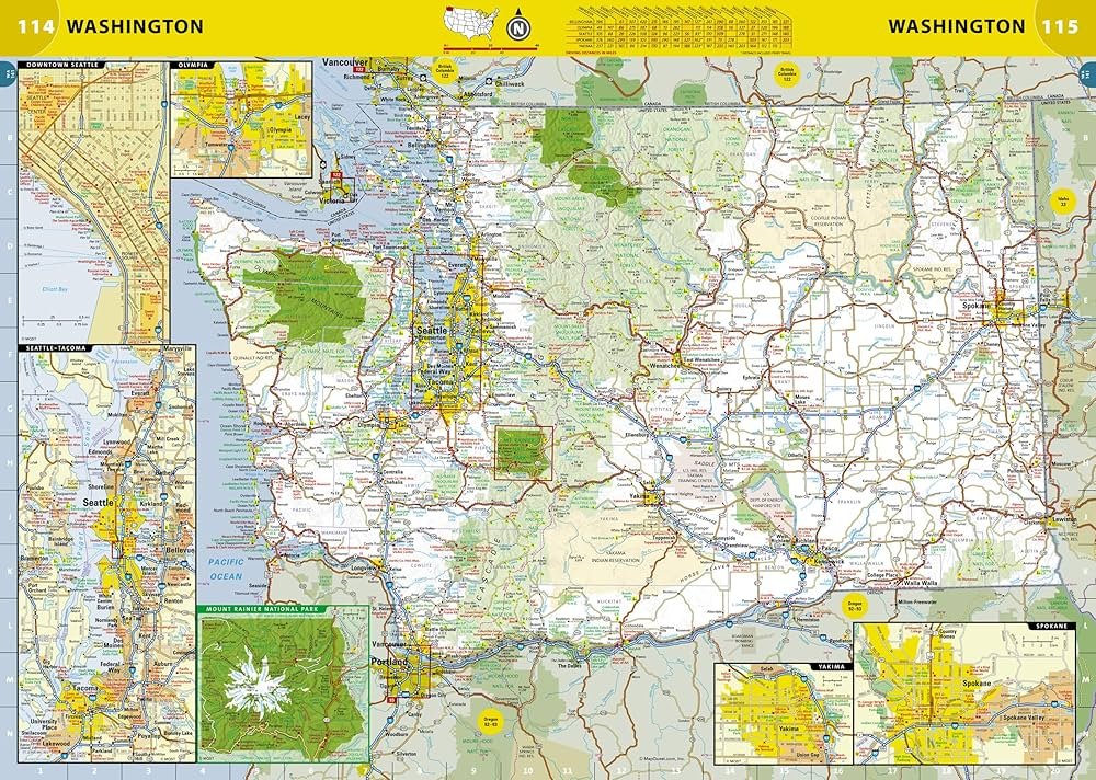
What sets this atlas apart is its attention to detail. Each map is meticulously crafted, with clear, easy-to-read fonts and vibrant colors that highlight everything from major highways to scenic byways. The atlas also includes topographic details, such as mountain ranges and elevation changes, which are invaluable for hikers, campers, and outdoor enthusiasts. Whether you’re planning a route through the rugged Rockies or a coastal drive along the Pacific Coast Highway, the National Geographic Road Atlas Adventure Edition ensures you have the information you need to navigate with confidence.
Designed for the Adventurous Spirit
One of the standout features of the National Geographic Road Atlas 2025: Adventure Edition is its emphasis on adventure destinations. The editors at National Geographic have curated a list of America’s top 100 adventure spots, ranging from iconic national parks like Yellowstone and Yosemite to lesser-known treasures like the Great Smoky Mountains’ backcountry trails. These destinations are highlighted throughout the atlas, complete with brief descriptions, coordinates, and tips for making the most of your visit.
For example, while flipping through the pages, I stumbled upon a feature on Arches National Park in Utah. The atlas not only provided a detailed map of the park’s roads and trails but also suggested the best times to visit for optimal weather and fewer crowds. It even included a note about nearby camping options and a scenic drive to nearby Canyonlands National Park. This kind of curated content transforms the atlas from a simple navigational tool into a source of inspiration, encouraging you to explore places you might not have considered otherwise.
The atlas also includes a comprehensive recreation guide, which is a goldmine for outdoor enthusiasts. From kayaking spots along the Colorado River to ski resorts in the Sierra Nevada, the guide covers a wide range of activities, complete with contact information and seasonal recommendations. For families, this section is particularly helpful, as it points out kid-friendly destinations and activities, ensuring everyone in the group has a memorable experience.
Read more: Radiant Eyes with Beautology Lab Gold Eye Gel Pack A Skincare Experts Review
Practical Features for Seamless Travel
Beyond its adventure-focused content, the National Geographic Road Atlas Adventure Edition is packed with practical features that make it a must-have for any traveler. The atlas is printed on durable, high-quality paper, with a spiral binding that allows it to lay flat on your dashboard or campsite table. At 11” x 15” and 168 pages, it’s compact enough to fit in a glove compartment or backpack but comprehensive enough to cover vast regions in detail.
One of my favorite features is the extensive index, which makes it easy to locate cities, towns, and points of interest. Whether you’re searching for a specific campground in British Columbia or a historic site in New Mexico, the index is intuitive and well-organized. The atlas also includes mileage charts and driving times between major cities, which are incredibly useful for planning multi-day trips. For international travelers, the inclusion of Canada and Mexico is a major plus, with detailed maps of popular destinations like Banff National Park and the Yucatán Peninsula.
Another thoughtful touch is the atlas’s focus on scenic routes and historic sites. As someone who loves taking the road less traveled, I was delighted to find recommendations for drives like the Blue Ridge Parkway and Route 66. Each scenic route is accompanied by a brief description of its highlights, such as roadside attractions, overlooks, and cultural landmarks. This feature encourages you to slow down and savor the journey, rather than rushing from point A to point B.
Why It Stands Out in a Digital Age
In an era dominated by GPS apps and digital navigation, you might wonder why a physical atlas is still relevant. While I’m a fan of technology, there’s something uniquely satisfying about flipping through the pages of the National Geographic Road Atlas Adventure Edition. For one, it doesn’t rely on cell service or battery life, making it a reliable backup for remote areas where signal is spotty. I’ve had countless experiences in places like the deserts of Nevada or the mountains of Montana where my phone’s GPS failed me, but a trusty atlas never does.
Moreover, the atlas offers a level of context and inspiration that digital tools often lack. Apps like Google Maps are great for getting you from one place to another, but they rarely highlight the hidden gems or scenic detours that make a trip memorable. The National Geographic Road Atlas Adventure Edition fills this gap, encouraging you to explore with curiosity and intention. It’s not just about reaching your destination—it’s about discovering the stories, landscapes, and cultures along the way.
That said, the atlas isn’t meant to replace digital tools entirely. Instead, it complements them, offering a tangible, big-picture view of your journey. I often use the atlas to plan my route and identify points of interest, then rely on my phone for real-time navigation. This hybrid approach allows me to balance the reliability of a physical map with the convenience of technology.
Read more: Best Car Mobile Stand with Charger for 2025 Ultimate Guide
A Tool for All Types of Travelers
One of the greatest strengths of the National Geographic Road Atlas 2025: Adventure Edition is its versatility. It’s designed to cater to a wide range of travelers, from solo adventurers to families, RVers to backpackers. For road-trippers, the atlas’s detailed highway maps and mileage charts make it easy to plan efficient routes. For outdoor enthusiasts, the recreation guide and topographic details provide a wealth of information for hiking, biking, and camping. And for those who simply love to explore, the curated adventure destinations and scenic routes offer endless inspiration.
Families, in particular, will appreciate the atlas’s focus on accessible, crowd-pleasing destinations. The inclusion of national parks, historic sites, and family-friendly activities ensures there’s something for everyone, whether you’re traveling with young kids or teenagers. The atlas also highlights rest areas and visitor centers, which are lifesavers on long drives with little ones in tow.
For international travelers, the maps of Canada and Mexico are a major draw. Whether you’re dreaming of a coastal drive in Baja California or a cultural tour of Quebec City, the atlas provides the same level of detail and care as its U.S. maps. This makes it an excellent resource for those planning cross-border adventures.
Areas for Improvement
While the National Geographic Road Atlas Adventure Edition is exceptional in many ways, it’s not without its flaws. For one, the sheer amount of information can feel overwhelming at times, especially for first-time users. The maps are densely packed with details, which is great for experienced navigators but might be intimidating for beginners. A brief “how to use this atlas” section at the beginning could help new users get the most out of its features.
Additionally, while the atlas covers a wide range of adventure destinations, I would love to see more emphasis on urban adventures. Cities like Austin, Portland, and Montreal have vibrant outdoor and cultural scenes that would appeal to the atlas’s target audience. Including a few city-specific maps or recommendations could broaden its appeal even further.
Finally, the atlas could benefit from a digital companion app or online portal. While I appreciate the tactile experience of a physical atlas, a digital version with interactive maps, real-time updates, and trip-planning tools would enhance its functionality. National Geographic has the resources and expertise to create such a platform, and it would be a natural extension of the Adventure Edition brand.
Read more: Top Samsung Galaxy S22 Ultra Car Holders for Secure and Stylish Drives
Why It’s Worth the Investment
At a retail price of around $30, the National Geographic Road Atlas 2025: Adventure Edition is a fantastic value for what it offers. With 168 pages of detailed maps, curated adventure destinations, and practical travel resources, it’s a one-stop shop for planning and executing epic journeys. Compared to other road atlases, it stands out for its focus on adventure, its high-quality production, and its connection to National Geographic’s legacy of exploration.
For me, the true value of the atlas lies in its ability to spark curiosity and inspire exploration. Every time I open it, I find myself dreaming of new destinations, from the red rock canyons of southern Utah to the misty forests of British Columbia. It’s a reminder that the world is full of wonders waiting to be discovered, and with the National Geographic Road Atlas Adventure Edition in hand, you’re well-equipped to find them.
Final Thoughts
The National Geographic Road Atlas 2025: Adventure Edition is more than just a map—it’s a love letter to the spirit of adventure. Whether you’re embarking on a cross-country road trip, a weekend camping getaway, or a family vacation, this atlas is your trusted companion, guiding you through breathtaking landscapes and hidden gems. Its combination of detailed cartography, curated adventure destinations, and practical travel resources makes it an indispensable tool for explorers of all kinds.
As someone who has spent countless hours on the road, I can say with certainty that this atlas is one of the best investments you can make for your travels. It’s a testament to National Geographic’s commitment to fostering a deeper connection with the world, and it’s a must-have for anyone who believes that the journey is just as important as the destination. So grab your copy, chart your course, and get ready to discover the wonders that await.